
We laugh in the face of Iraq’s sandstorms…! OK, so maybe our flying dirt events don’t last as long, but they can be pretty dramatic in their own way. Take last evening for example. Odessa, our neighbor a mere 20 miles to the west, had 80 mph winds and torrential downpours. Big Spring, our neighbor 40 miles to the east had some heavy winds and torrential downpours. Here in Midland, however, we had…well, let’s save a couple thousand words, shall we?
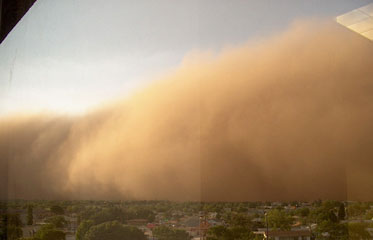
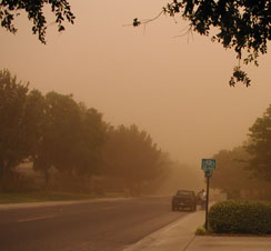
The top photo was taken by an unidentified person from an upper-floor office (you can make out the reflection of the window if you look closely). I took the bottom photo from my driveway in what should have been bright daylight; it’s not a sepia photo…this is unretouched Midland environment at its worst. The really awful thing about this particular storm was that the wind died quickly, and the dust just hung in the air for hours. This may be even worse that those times when the dust is mingled with just a touch of precip, giving everything a wonderfully yucky coating of mud. (Watch “Dante’s Peak” for a similar, if a tad more dramatic, effect.)
Oh, by the way…let’s just keep this our little secret, OK? I’d hate for our Chamber of Commerce to find out these kinds of photos are making it onto the Internet!
Discover more from The Fire Ant Gazette
Subscribe to get the latest posts sent to your email.